Saturday 14 August 2010

Thursday 12 August 2010 Faringdon

One week ago Alcyone arrived back to her home port of Hythe. A quick stripping of the boat to remove all fresh food and dirty laundry and then home for a family dinner, a huge pile of correspondence and sleep. A couple of days sleeping and dealing with accounts and correspondence and then back to Alcyone for cleaning.


There has been time to reflect on the cruise.

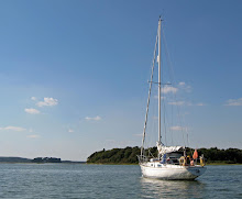
We were away for 83 days and covered 1,880 miles. The longest days passage was 141 miles from Scarborough to Great Yarmouth and the shortest was 2 miles from Corpack Basin to Banavie on the Caledonian Canal (but that did include Neptune’s Staircase) or, in open sea, 4 miles from Portavadie to Tarbert. Of the 83 nights, 54 were sent in marinas of one sort or another, 8 on pontoons, 10 alongside a wall, 8 on moorings and (rather surprisingly) only 1 at anchor with 2 nights at sea. For much of the time we had light winds from ahead. A spinnaker was carried round Britain but stayed in its locker; only once did we rig the spinnaker pole to boom out the genoa.

The nature and quality of the various marinas was very variable but the prize for the best facilities must go to Portavadie. It was magnificent! The worst; well ..............

Inevitably there were some ‘magic moments’ – a combination of weather, place and people. Motoring between Mull and the mainland when William announced that we should have something hot for lunch, would I like cheese on toast?; he disappeared below, then popped up to announce he could not cook without music – may he plug his iPhone into the radio; then popped up again to announce that he had chosen the most innocuous music; then slices of cheese on toast being passed up. Or anchoring at Lindesfarne for lunch and exploring into the harbour. Or the wonderful anchorage at Carrick Castle, Loch Gail. Or sitting on a bench on the foreshore at Grimsby Sound, Tresco with a pint looking out over the sound.

But the final word can go to Robin Wills whom we met in Dunstaffnage, Oban in his new Malo 38. By email a few days later, having sailed back to Portsmouth, he commented  “ ..... but the strong depression over the Hebrides meant we had 25 knots of wind and two wave trains each of 2 metres with the occasional peak, or trough, of 2.5 to 3 metres. We fell off a couple of waves but otherwise Cantata II coped well with only two offerings for the helmsman. Whilst a Co32 would not have fallen with such a pounding we would have been much wetter...........”

Next time .........


Saturday 7 August 2010

Thursday 5 August 2010 Hythe N 50 52.80' W01 24.50’


The last passage home.

Alcyone left Brighton at 0530 bound for Hythe with a Force 3 wind and moderate sea. The forecast had promised North West Force 4 to 5 wind backing south west in the middle of the day which would have given a reach to the Solent then a reach, on the other tack, up the Solent and Southampton Water but, true to form, the wind was ahead only a few degrees north of west making it close hauled all the way. At least the sun shone for most of the way!


Clearly others had also seen the forecast and worked out the optimum time to leave to get maximum tide as there were at least 10 boats beating down channel out of Brighton as we set course for the Looe Channel. Many seemed to head further offshore and within a couple of hours we were alone.

At 1530 hours Alcyone entered Hythe Marina at the end of some 2,000 miles and 12 weeks of sailing.


Wednesday 4 August 2010

Wednesday 4 August 2010 Brighton N 50 48.66’ E 00 06.03’


Frustration. The intention was to make the final passage along the south coast back home to Hythe. Needless to say the weather was not inclined to oblige. The forecast for today predicted south westerly wind Force 4 to 5 with occasional periods up to Force 6 or 7, all accompanied by rain and poor visibility; the forecast for Thursday suggests north westerly wind backing south westerly Force 4 to 5. Hence the decision is to stay in Brighton for one more day and make the home passage on Thursday.


Tuesday 3 August 2010 Brighton N 50 48.66’ E 00 06.03’


The tide allowed a leisurely start from Eastbourne and, at least initially, was a most enjoyable passage until it clouded over. The wind on leaving Eastbourne was very light but it gradually got up to a Force 4.


Passing the white cliffs of Beachy Head was spectacular in the sunshine. Arriving at Brighton Marina was somewhat unnerving – there is a wave reflection off the breakwater giving a very confused sea as one approaches the marina and the entrance is narrower than might be anticipated but once inside the protection is total.

Brighton Marina is huge. Wide fairways and aisles between the main pontoons. And all conceivable facilities with a substantial commercial centre with various restaurants, pubs, shops and the like as well as boat yard and repair facilities. However it is not full with many empty berths and many boats obviously not used for a long time with luxurious growth on the hull.

Monday 2 August 2010

Monday 2 August 2010 Eastbourne N 50 47.52’ E 00 19.55’


An early start to catch the tide along the south coast to Eastbourne and the huge Sovereign Harbour Marina complex. Much of the passage was a flat calm with some sun and a smooth sea.

At Ramsgate we noticed the large number of European yachts particularly Dutch yachts and this has continued in Diver and Folkestone. At one point a flotilla of some 10 or more Dutch yachts passed us bound east.


Sunday 1 August 2010 Dover N 51 07.25’ E 01 20.61’


Refreshed, Alcyone left Ramsgate for Dover with a Force 4 wind from the south to south west. The sea became very lumpy as we approached Dover and began to deal with the port traffic control procedures required. For obvious safety reasons the port procedures for Dover are strictly enforced but the port is very helpful; according to the Pilot Book, launches come out to escort yachts into the harbour when required. Many harbours that we have visited have similar systems – those at Dover seem warranted whereas others seem excessive.


Dover is a large port; the ferry terminals occupy just a small area at the eastern end of the bay with the cruise terminal and other commercial quays in the western end and the yacht marina situated in the old harbour. Crossing the harbour from the eastern entrance to the marina brings home the size of the place. But when exploring on land, by foot, I was surprised to find also within the harbour area a beach and water sports area and resort facilities.

Before setting off on the cruise one acquaintance referred to the last leg as being “come round the corner at Dover and into the south west monsoon”. It looks as though this prediction might come true!

Sunday 1 August 2010

Saturday 31 July 2010 Ramsgate N 51 19.69’ E 01 25.25’


A make and mend day in Ramsgate. And a look around Ramsgate, including Waitrose.

Early morning the marina basin emptied as yachts set off to catch the tide to cross the Thames Estuary and then throughout the day yachts arrived. One interesting arrival was a Contessa 26, sailed by two young men, that started in Norway, crossing to Venezuela and was now on her way back to Norway; attached to her backstay were what looked like feathers and a bird skeleton supplied by the witch doctor, no doubt, to ensure safe passage.


Ramsgate has a long standing maritime heritage being built originally to offer shelter for ships in the Downs – the traditional anchorage between the mainland and Goodwin Sands. The harbour is the centre of the town. There is a Maritime Museum, opened so it proudly declares by Ted Heath some 35 years ago but now giving the impression of terminal failure. However on the outside to the building are two intriguing statements; “Ramsgate mean time is 5 mins 41 seconds faster than this clock” and “The first stroke of this clock at the hour of 12 indicates Greenwich Mena time”. On the harbour side is an attractive building with the notice “Ramsgate home for smack boys founded 1881”.

Friday 30 July 2010 Ramsgate N 51 19.69’ E 01 25.25’


We left Burnham-on-Crouch at 0800 hours, dictated by tide to cross the sandbanks of the Thames Estuary, bound for Ramsgate. A very trying passage. The wind started as a flat calm, then gradually increased as the day wore on to Force 4 to 5 from ahead accompanied by an unpleasant lumpy sea. Occasional rain completed the picture. Much of the time was motoring sometime with sails set, sometimes without. Alcyone’s course was up the Whittaker Channel, across Black Deep and across the Sunk Sand, to where the Sunk Tower used to be, and into Barrow Deep and then into Fisherman’s Gatt and escape (or so it seemed) the southern estuary. It was unnerving to be out of sight of land crossing the Sunk Sands with only 3 meters of water at times. It was with relief that the white cliffs of North Foreland and then round to Broadstairs and Ramsgate appeared.

On arriving at Ramsgate, even before Alcyone was fully berthed and lines made fast, various skippers appeared wanting to know what route we had taken across the estuary. Stories abounded of water depths experienced – the winner seemed to be a 36 foot yacht that had come across between Black and Barrow deep on a “new route” and only had 2 meters of water.

Ramsgate Marina has long pontoons forming a basin for visiting yachts in which boats raft up, totally unsupervised by the Harbour Master. Chaos. Alcyone found herself between two much larger boats with the outer one declining to move to a more suitable berth. During the night, for HW ± 2 hours, it became agitated in the harbour with all boats rolling around, mercifully without any serious damage beyond lost sleep and wet pyjamas.


Saturday 31 July 2010

Thursday 29 July 2010 Burnham on Crouch N 51 37.50’ E 00 48.23’

The final East Coast River, before pushing on south and westward for home, was the River Crouch.

From the Walton Backwaters, Alcyone sailed to the River Crouch with Force 4 to 5 winds from the north west backing later to west. No sunshine but no rain, although poor visibility. This was our first taste of navigating in the Thames Estuary and picking a passage through the sand banks; after depths in excess of 100 meters in the Clyde and western Isles, it is a little unnerving to be picking a route through depths of 5 or less meters offshore. The huge wind farms make for a further restriction on choice of routes.

As we left the Backwaters, passing another boat – a traditional wooden Dutch looking yacht – the skipper called across to us that out boat was the most beautiful boat ever. I am not sure how he recognised Alcyone particular merits amongst other Contessa 32s, particularly with her present grubby topsides.

The few days in the East Coast Rivers were always part of the plan as an area I wished to explore. But of course four days is only a taster. Nevertheless enjoyable and definitely an area to be returned to again. Before arriving in the area, I read again Maurice Griffith’s wonderful book “Magic of the Swatchways”. It is easy to understand why he formed such an attachment to the area. The changing landscape as the tide ebbs exposing large areas of mud banks. The causal acceptance (so it seems) of very limited water depths. The huge variety of boats with a significant number of older wooden traditional designs. But above all the flatland and huge skies – almost impossible to photograph but so impressive.

Wednesday 28 July 2010

Wednesday 28 July 2010 Titmarsh, Walton Backwaters N 51 51.79’ E 01 15.36’

The exploration of the Suffolk Rivers, and I suppose the Essex Rivers, continued today with a visit to the Walton Backwaters. This was always on the original plan and for some time has been a place I have wished to visit – maybe shades of Arthur Ransome “Secret Waters”. It does not disappoint. The view up Hanford water as we entered the Backwaters is breathtaking but we turned south into the Twizzle for Titmarsh Marina.


The marina give the impression of being one of the oldest in the country. It certainly is well established. Surrounded by flood bunds it looks out over the tidal mud flats of the Backwaters. Wandering around the marina what must be one of the ugliest boats was spotted; pale blue with a curious shaped hull, huge topsides and short dumpy mast.

The sail down was gentle with variable Force 3 to 4 winds, sunshine and no rain.


Tuesday 27 July 2010 Wolverton, River Orwell


Alcyone explored up stream from Ramsholt as far as tide and time would permit but regrettably not as far as Woodbridge. The River Deben may or may not be the prettiest river in England but it certainly is one of the prettiest. The landscape is gently rolling farmland with golden fields with the crops (or lack of rain) and dark green hedges and woodlands. And huge skies – I am sure that they cannot be larger than elsewhere and just seem larger due, no doubt, to the flat landscape.

And there is a lot of boating activity as well as boats on moorings; the variety of boats is also more interesting than in the Solent area with fewer ‘plastic fantastics’ and many more older wooden boats. The moorings and yacht clubs, as we passed seemed to be busy, with families on holiday.


From the River Deben we turned south again to return to the River Orwell, up past Felixstowe, and Pin Mill. The wind was, as might be expected from ahead and light and changeable. The it rained – not just average rain but heavy torrential rain that blocked out visibility and hammered down. Rain showers continued on into the evening when we were safely berthed in Wolverstone Marina.

Tuesday 27 July 2010

Monday 26 July 2010 Ramsholt, River Deben N521 01.25’ E01 21.66’


A wonderful sail round from Shotley to Ramsholt on the River Deben to meet up with Roger Graham of Contessa 32 “Wight Wizard”. Westerly Force 4 wind and sun! Getting over the Deben bar was less problematical than the pilot book suggested and proceeding up river we met up with Roger Graham who led us up river to Ramsholt. A pleasant lunch in the local hostelry.


Sunday 25 July 2010 Shotley, River Stour N51 57.63’ E01 16.68’

A fast passage from Lowestoft to Shotley Marina, in the River Stour. For most of the way the wind was light, 5 knots or less, but on the beam (or nearly) with occasional Force 4 giving a close reach.


The coastline has changed to very flat with long estuaries and, compared to what we have seen for many weeks, a huge amount of sailing boats out. Walking along the flood bund from the marina gives a very different landscape view to anything we have seen so far. I have been to this area before for Oppie National Championships many years ago, on holiday, but most particularly to visit Felixstowe on businness. It is somewhat different to be entering the estuary past the container terminals in one's own boat.

Saturday 24 July 2010

Friday & Saturday 23 & 24 July 2010 Lowestoft N52 28.32’ E01 45.11’


Two days in Lowestoft in the Royal Norfolk & Suffolk Marina. It has been crew change day again but for the last time on this cruise; Mathew has departed and Keith has joined.

Exploring Lowestoft almost felt as though one should record that Lowestoft has closed. Despite being a holiday resort there seem to be few holiday makers here and less for them to do – even the funfair was closed. The shopping centre has a selection of well known shops plus a lot of lesser outlets and charity shops and few customers.


Thursday 22 July 2010 Lowestoft N52 28.32’ E01 45.11’

A morning of exploration in Great Yarmouth and then a short hop down the coast to Lowestoft. The crew were less than complimentary about being berthed on the Town Quay at Yarmouth with its lack of facilities and wished to have a few more (some) mod cons (Showers).


Yarmouth Harbour is the river with quays along both banks. The Town Quay where we berthed is some 2 miles up stream. The main traffic today is supply boats for the north sea oil and gas rigs; it claims to be the largest supply boat port.

Herring has been a continuing factor in all the harbours visited down the eats coast from Lossimouth, in the Moray Firth, to Great Yarmouth and further south. Due to over fishing, the massive herring shoals along the north sea coast disappeared over the first decades of the 20th century and were almost extinct by the late 1930s. But the ‘silver darlings’ exerted a mighty pull. They dictated the migration of fishing fleets down the north sea as the boats and shoreworkers followed the shoals. In the autumn the herring ceased their southward journey off East Anglia and Great yarmouth and Lowestoft grew to accommodate the industry. Whilst it can be argued which port was the largest herring port, the vastness of the industry cannot be argued. Great Yarmouth accommodated over 1,000 herring boats in its heyday. Photographs of the boats arriving or departing give a whole new meaning to congestion. A herring drifter provided work for 100 people ashore gutting, filleting, salting and smoking. Trains arrived from Scotland bring the ‘herring girls ’ who followed the fish. It was a short but frantic season in Great Yarmouth from September to December. Sixty herrings a minute were gutted by one person working 14 hours a day.

Moored just astern of Alcyone was ‘Lydia Eva’, the last of the steam herring drifters. She was launched in 1933 and caught her last catch in 1938. Whilst looking old fashioned against today’s ships but she was very sophisticated in her day with electricity on board and wireless. A tour of the ship was thought provoking as to how sailors of that era lived and worked – Mathew was particularly taken with the idea that all the crew including Skipper lived in a single cabin and only had straw palliasse to sleep on and no washing or toilet facilities.

Our wandering us the took us through the Historic South Quay to the Herring Museum and Time and Tide Museum. Both have been built into old herring smokeries and told the story of the herring industry. One could peer up into the rafters at the smoking racks with the models to show men climbing to hang the fish.


Continuing on brought us into the present day on the sea front. A shock. Ugly 1960s style buildings jostled with amusement arcades and funfairs.

When we were on board 'Lydia Eva', moored alongside was an Albin Vega yacht - not in the first flush of youth - sailed by a Swede and crew he had picked up  in the pub the previous evening. One hears stories of boats having  no charts on board and being navigated by a road atlas. This was the case, the atlas clearly visible on the bridge deck. The crew of 'Lydia Eva' tried to get some charts but without success.

Alcyone left Great Yarmouth bound for Lowestoft, just 6 miles down the coast. A boisterous sail in Force 4 to 5 wind from ahead of course.

Wednesday 21 July 2010

Wednesday 21 July 2010 Great Yarmouth N52 36.36’ E01 43.45’

The original plan was to sail round Britain in about 60 mile passages, a minimum of overnight passages and following to coast to visit as many places as possible.

Planning somehow came unstuck in getting to Great Yarmouth. The distance from Whitby to Great Yarmouth is some 160 miles; making the short leg to Scarborough reduces the theoretical mileage to 140 miles. Intermediate harbours are the Humber Estuary, either anchoring off Spurn Point or Grimsby Marina, and Wells-next-the-Sea. Spurn is a good passage anchorage if the wind is from the north or east but exposed to south to west. Grimsby Marina is in a locked basin with access only at HW ±2.00 hours; high water for Wednesday was approximately at 0230 BST. Wells-next-the-Sea has limited water depth; the Harbour Master advised that we could get in on Tuesday but would then be neaped until at least Saturday before having sufficient water to get out. Hence it was decided to do the leg to Great Yarmouth in one.

Alcyone left Scarborough at 1030 hours Tuesday and arrived in Great Yarmouth by 1300 hours Wednesday. This is the longest passage I have done in Alcyone and the longest for some time. The forecast had promised light winds with talk of south easterly winds going round to the west. In the event, we had up to some 20 knots on the nose for much of the way. The sea was very lumpy across the Humber Estuary leaving us both feeling somewhat jaded due to effects of ‘mal du mare’. However, coming down the Lincolnshire Coast in the morning was again glorious with sunshine, and a fresh breeze.

The first part of the passage was along the North Yorkshire coast to Flameborough Head, white limestone cliffs providing a contrast to the previous coast line of brown sedimentary rock cliffs. Then, as the coast fell away, we continued out to sea to cross the Humber shipping lanes and oil and gas platform infested seas; we seemed to pass far more platforms than were marked on the chart and there was a continuous shipping movement. The supply boats in particular appeared to be a law unto themselves; for no apparent reason they would suddenly start into motion and follow us or shadow us. The platforms light up at night looked very impressive. Approaching Great Yarmouth the Norfolk coastline becomes low flat lands with long uninhabited beaches which looked wonderful in the morning sun. And finally the Scroby Wind Farm clearly visible for many miles and appearing to be a block on the channel to Great Yarmouth.

Then arriving at Great Yarmouth. One Pilot Book refers to the port not being welcoming to yachts – this is a gross understatement. The polite word might be unhelpful. But nevertheless we made it up river to the Town Quay to moor against the old quay wall in difficult tidal conditions. With modest investment it could be an excellent yacht harbour without in any way impacting on the oil industry supply boat trade; one local commented that the Council is only interested if it is amusement arcades and funfairs!