Friday, 16 July 2010

Thursday 15 July 2010 Sunderland N54 55.14’ W001 22.01’


At 0730 hours Alcyone escaped from Amble and once more turned south, this time bound for Sunderland. There was a surprisingly large sea running but with little wind although it did get up to Force 5 through the day. We arrived in Sunderland by 1400 hours. And after some confusions berthed in Sunderland Marina.

The port at Sunderland had become outdated with little or no traffic. But over the past few years has been upgraded; the new marina is part of that upgrading with the marina built in one of the old docks and housing development all round to make an attractive facility. Walking along the coast out of town it is surprising the extent to which it is a holiday resort with a promenade. The old outer breakwater with its lighthouse on the end is an attractive feature.


One reason for electing to come to Sunderland is that the firm for which I worked for over 30 years, Halcrow, started as Thomas Meek & Sons and the first project to which they can lay claim is a lighthouse in Sunderland. It was not regrettably the one on the end of Roker Pier, the outer breakwater. As far as I could determine, it was originally erected on the South Pier in 1865 but in 1983 was dismantled and re-erected on the sea front to the north of thee town. At present it is surrounded in scaffold being repainted – I was told it had to made to look it’s best for the forthcoming air tattoo.


Wednesday, 14 July 2010

Wednesday 14 July 2010 Amble, Warkworth Harbour N55 20.18’ W001 35.12’


A day in Amble Marina. This was partially because of less than good weather forecast but more particularly to fit in with arrangements to meet up with Ted’s niece and family that live in this area.


Entrance to Warkwoth Harbour is somewhat un-nerving from seaward. As we approached, at high water, there were waves braking on both sides of the entrance. And there the un-buoyed Pen Bush shoal is across the entrance. Looking today from the breakwater end, at low tide there were breakers all across the entrance as well as breakers on the offshore shoal. Coming into the harbour there is a lack of buoys or marks and sundry derelict timber structures as well as what appears to be a new quay wall with clear signs of settlement. Entering the marina there is an incongruous red buoy with a small gap to port between it and a derelict jetty; this is the gap for the cill and entrance to the marina despite the more obvious (at high tide) gap to starboard of the buoy.

The port was built as a coal port and handled its last collier in 1969. Today amongst the dereliction there are a few fishing boats plus the marina.

The marina boast being a “small family run business” but is not to be recommended. It is expensive (at least for this area), tidally constrained, poor facilities and to cap it all wants to charge 5% additional fee for use of a credit card.


Ted joined the Alcy1 Race Crew on Hungry Tiger for the Round-the-Island Race and has clearly been got at with regard to mobile phones. He now has a smart iPhone and has caught the associated disease of never putting it down.

Late afternoon, Ted's niece and family plus two school friends came on board to have a look at Alcyone before going onto dinner. A most enjoyable evening.


Tuesday 13 July 2010 Amble, Warkworth Harbour N55 20.18’ W001 35.12’


Another glorious day sailing southwards past a flatter landscape and castles on headlands and, of course, Holy Island and the Farne Islands. Again light winds from the south east or east, very light in the morning but increasing slightly in the afternoon. And again with sunshine much of the way. Arrived in Warkworth Harbour late afternoon as the rain clouds gathered.

Passing Berwick on Tweed, from Scottish water s to English waters the courtesy flag flown at Alcyone’s crosstrees was lowered. We were now back in England, the last English port having been Padstowe.


Rather than pass the Farne Islands to seaward, we chose to take the inshore passage. The citadel at Holy Island is clearly visible from way out. Then gradually the village of Lindersfarne comes into view. Alcyone navigated into the harbour at Lindesfarne, anchoring for lunch in the sunshine. As we came up the channel into the harbour we were surrounded by sealions – in one case a group of 6 that popped up to take a look at the intruder. (Unfortunately none of the photos taken are worth reproducing). The calls of the sealions on the exposed rocks punctuated conversation over lunch.

The on, close inshore, past Bamburgh Castle looking imposing on its headland. Bamburgh is the home of the Grace Darling Museum commemorating the bravery of the lighthouse keepers daughter in rescuing passengers and crew from the stricken steamer aground on the Harcar Rocks.

Then on through the Farne Islands themselves.


Monday 12 July 2010 Eyemouth N55 52.52’ W002 05.29’


Eyemouth. And after a wonderful day at sea. Breeze was generally light Force 2 or 3 but with sunshine most of the way. The lock gate at Arbroath opened at 1200 hours and a rapid passage was necessary to get to Eyemouth before there was insufficient water to get in through the harbour to the yacht pontoon and hence we motor sailed most of the way, making between 6 and 7 knots. A Contessa 34 ‘Magic Moon’, that we first met in Peterhead, arrived an hour or so later and gracefully went aground on the bank in the middle of the harbour but managed to extract herself to the fish dock; next morning she disgraced herself by leaving without paying – with much muttering from the Harbour Master!

Eyemouth is a working fishing port, unlike many not a ‘has been’ fishing port. However they do actively welcome yachts. it is known for a disaster on Friday 14 October 1818 when out of a clear blue sky a gale sprang up and sunk 23 fishing boats.

Sunday, 11 July 2010

Sunday 11 July 2010 Arbroath N56 33.361’ W002 35.033’


It should have been Eyemouth but the forecast was not considered by the crew to be conducive to good sailing – for some reason beating into 60 mph ‘gusts’ (which seem to last for minutes or hours) did not find favour. Looking out to sea, this morning off Arbroath it appeared to be a Force 5 or 6 south east breeze with the promised gusts to come; the course to Eyemouth is south east. A day in Arbroath. Tomorrow Eyemouth?

Saturday, 10 July 2010

Saturday 10 July 2010 Arbroath N56 33.361’ W002 35.033’


Rain drizzle and poor visibility all with no wind is the order of the day. It is crew change day and Alcyone will remain in Arbroath until at least tomorrow. Hopefully the weather as forecast will improve and we can get back out to sea.

Today is crew change day. Ted is re-joining, arriving by train late this afternoon and Guy R departs tomorrow morning for the delights of refurbishing Rosyth Navel Dockyard.


The round Britain cruise has now been 8 weeks with a further 4 to go against the original plan. Arbroath was originally planned as a crew change day and hence we are on schedule – given more clement weather we could have been exploring the Firth of Forth and maybe even the delights of Edinburgh. As Roger & Josie commented on Nordleys, we now have the flog down the east coast but, unlike the past week plenty of harbours and places to go.


Friday, 9 July 2010

Wednesday, Thursday and Friday 7, 8, & 9 July 2010 Arbroath N56 33.361’ W002 35.033’


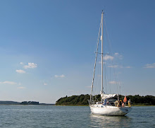
The forecast was not good and certainly not suitable for two old codgers to make the next stage particularly in rough weather, including the still promised Force 9 or 10. Hence a few days rest in Arbroath.

Wednesday was a ‘make and mend’ day as various squalls come and went. It was good to have the cockpit canopy to shelter us from the worst of the rain.

On Thursday, we made a bus trip to Dundee to do the tourist bit particularly to visit Scott’s ship “Discovery” and the Polar Experience at Discovery Point. The countryside is very different from the highlands; we are very much now in the lowlands with rich agricultural land as far as we could see.

The Polar Experience exhibition is excellent and fully brings to life the hardships and privations of polar exploration at that time. The Discovery and the voyages she made are very thought provoking. A triple planked hull of different woods to give the strength to withstand being locked in the ice. A sailing ship with traditional square sails but an auxiliary steam engine. The wardroom chairs bolted down on swivels to allow people to turn round. And bunks along the side of the ship – apparently if a mattress touched a hull bolt or iron knee, it froze solid overnight and had to be thawed out before it could be moved. We were pondering how the crew got out onto the yards from the ratlins as it seemed a very long way to jump.


Then we walked along the waterfront to visit the Unicorn, a ship of the line dating from the Napoleonic Wars. She was built in Chatham but never rigged as the wars ended before she could be commissioned; she then became part of the ‘strategic reserve’ in case war with France broke out again, then a training ship and finally headquarters for the RNVR. During the First and Second World Wars she was based in Dundee as headquarters for the navy. She was finally de-commissioned in the 1960s and sold for £1 to a charity to preserver her. Because of her peculiar history she is claimed to be the best preserved ship of the line of her time.


Amongst the showers and squalls, Friday was again make and mend plus exploration of Arbroath.

The town began with the foundation of Arbroath Abbey. This was founded in 1178 by King William the Lion. Today it is a large ruin.


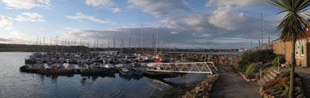
Arbroath’s first harbour was originally built in 1394 at Danger Point by the Abbot. But it was destroyed in a gale and another harbour built around 1734. The present harbour was begun in 1842 and was completed with the opening of the wet dock in 1877. Subsequently further breakwaters were built to form the outer harbour. The harbour was originally a commercial port trading with North America, the Continent and around the coasts of Britain. The Town Council invited some fisher families to Arbroath in 1830 and the local fishing industry developed from that date. Today there is some fishing but the inner dock is predominantly given over to yachts.

The harbour at Arbroath is dominated by the Signal Tower, built over 200 years ago to communicate with the Bell Rock Lighthouse 11.5 miles off shore. The Bell Rock Lighthouse was built in 1810 by Robert Stevenson. Signalling was by means of copper balls hoisted to show all was alright; if no ball was seen on the lighthouse a boat was sent out to investigate. When a baby was born on shore to a keeper on the lighthouse, news of the birth was sent by hoisting a pair of trousers for a boy or dress for a girl.


Arbroath is of course famous for the Arbroath Smokie. Pairs of haddock are tied by their tails and suspended over square oak barrels some 1.5m square. They are hot smoked and cooked right through by various local families each with their own recipe. Today ther are several smokeries around the harbour with fish shops selling all manner of fish and seafood.


Thursday, 8 July 2010

Tuesday 6 July 2010 Arbroath N56 33.361’ W002 35.033’


The forecast for today was not ideal with predominantly southerly wind (i.e. on the nose) and rain showers, although only force 2 to 3 increasing late afternoon to force 5. But the forecast for the next few days was definitely not good with gusts of 42 mph and mention of severe gale Force 9 or storm Force 10. To make the next hop to Arbroath there are no good refuge harbours along the coast; Aberdeen does not welcome yachts and has no facilities and Stonehaven only has one berth, at the outer end of the harbour wall where one can lie afloat. Hence, it was decided to make a dash for Arbroath before the really bad weather closed in.

Motor sailing most of the way, we made a fairly quick passage; 65 miles in 14 hours, arriving off Arbroath at 1900 hours.


The Almanac stated that a green flashing light on the breakwater would indicate it is safe to enter the harbour and a red flashing would indicate it is unsafe to enter. The outer harbour dries out. The Pilot Book suggests that entry into the inner harbour can be made from mid tide to mid tide. With high water at 2200 hours, entering at 1900 hours we were at mid tide. No flashing lights were seen, nor was the noted red or green light indicating that the gate into the inner harbour was closed or open. We berthed in the inner harbour and presented ourselves to the Harbour Master to discover he was about to close the gate and go home; as we had not radioed in he did not know we were coming and hence had no reason to stay on. It does not bear thinking about what we would have done had the gate been closed – a night at sea perhaps in a rising wind. The moral is always radio ahead for permission to enter.


Monday 5 July 2010 Peterhead N57 29.81’ W001 46.42’


Departed Whitehills at 1130 hours to get the tide at slack water off Rattray Head. Another good sail in Force 2 to 4 winds from aft.

It is very noticeable that in all the Scottish waters, there are more seabirds that we are used to seeing in the English Channel. Approaching the headland of Fraserborough we noticed a huge gathering of gulls. Presumably this was over a fish shoal and the gulls had gathered for food or maybe a fishing boat had just dumped unwanted fish and/or entrails from filleting. There was no shallow patch or other feature marked on the chart.


Both in Lossimouth and Whitehills we had been receicing dire warnings about Rattray Head – tide race, overfalls, maybe the devil himself; clearly a Scottish answer to Portland Bill. Hence the decision to forgo fair tide to get the slack water at the headland. But in the event it was benign. Almost no tide even though we were early for slack water, no sign of overfalls (which are not marked on the chart).


Peterhead is an industrial harbour predominantly occupied with North Sea oil supply boats but with a large fishing harbour. A new yacht marina has been built in the south west corner of Peterhead Bay. Whilst not ideal, it does provide an excellent passage stop over. Because of the continuous movement of supply boats, traffic in and out of the harbour and movement within the harbour is strictly controlled with permission having to be sought by VHF for all movements; we were held outside to a short time waiting for two trawlers to leave and later not allowed to leave the marina until a supply boat had berthed.

Sunday 4 July 2010 Whitehills N57 40.815’ W002 34.700’


The forecast was not good for Sunday and we joined the several other boats in Whitehills waiting for better weather in order to make the next leg down the East Coast – or more precisely along the northern coast of Grampian before turning south to Peterhead. Despite the forecast, it was sunny and moderate winds such that by mid afternoon, after a walk along the foreshore, I almost suggested an evening sail to Peterhead. Then the wind came; howling in the rigging, the boat heeling over and rocking about in the inner harbour with mooring lines doubled. A bouncy few hours!

Walking along the coast from Whitehills present harbour, is the site of a brick and clay ware factory which was started in the 18th century and finally closed in the mid 20th century. It is the site of the first harbour at Whitehills where the coal and lime was brought in for the factory and finished goods taken out. Today it is part of the foreshore at a large caravan site. It looks about big enough to take a modest rowing boat – I would not like to have to take Alcyone into the harbour.

Monday, 5 July 2010

Saturday 3 July 2010 Whitehills N57 40.815’ W002 34.700’


Having waited for the tide give enough water to get out of Lossimouth, we set sail for Whitehills some 25 miles along the coast. Again a glorious sail with the wind behind the beam and a good south westerly Force 5 to 6.

Entering Whitehills Harbour is straight forward in reasonable weather providing one is ready for the very narrow entrance and tight turns with little or no manoeuvring room. But in an onshore wind, as the photograph in the entrance to the toilet block, it is not always easy. Until relatively recently this was one of many fishing harbours along the Scottish east coast. Today it has been converted for yachts with pontoon berths and all the facilities including, a first in my experience, a Day Room. It is definitely a harbour worth visiting.


To celebrate Guy’s birthday, it was decreed tat we should dine ashore. One pub had a hen party and would not take any other customers; the hotel had just had a wedding and the kitchen staff had gone home. Hence we dined at the local fish & chip shop – good but not quite Rick Stein.

Saturday, 3 July 2010

Friday 2 July 2010 Lossimouth N57 43.362’ W003 16.768’


We set out from the Seaport Marina, Inverness at 1045 hours to go through the last two locks of the canal and under the swing bridge – a railway bridge operated by Network Rail in consultation with the lock keepers but trains take precedence and hence getting an opening is less than straight forward. Alcyone finally left the Caledonian Canal at 1130 bound for Lossimouth.


As Alcyone came out into Inverness Firth, we noted Jim Prentice in Circe circling to guide us out through the narrows. It was great to sail in company with him, albeit only for a mile or two out under the bridge. The shallowness of the Inverness Firth had come as surprise to me – the majority of the area is less than 2m CD. The channel out is not well buoyed and somewhat tortuous.

For most of the day we enjoyed sunshine and brisk force 4 to 5 occasionally 6 breeze from the south west giving us a run or broad reach – not only is it unusual for this cruise to have wind but to have it from behind coupled with sunshine is a bonus. Throughout the afternoon it did die but came back again and we arrived in Lossimouth at 1900 hours in a sparkling force 6.


Thursday 1 July 2010 Inverness N57 29.104’ W004 14.920’

A day spent in Seaport Marina, Inverness. The original plan was to transfer round to Inverness Marina outside the canal to avoid delays associated with the final two locks and railway bridge to leave the canal.


In the evening Jim Prentice and his wife came on board for a beer or two. They sail Circe, a 1973, Contessa 32 based in Inverness.

Thursday, 1 July 2010

Wednesday 30 June 2010 Inverness N57 29.104’ W004 14.920’


Another leisurely day along the Caledonian Canal, in sunny and warm weather with little or no wind.


Leaving  the canal at Fort William you go out of the cut alongside what is claimed to be the smallest tower lighthouse in the world; today it is not used but stands as reminder of times gone by. Fort Augustus is half way along the canal although it has the majority of the locks and other structures. From Fort Augustus to Inverness is predominantly along Loch Ness with then a short amount of canal before the locks into Inverness. In Loch Ness we had a short detour to see Urhart Castle set in a beautiful bay, from the water. Then onto Seaport Marina in Inverness down the final flight of locks to be negotiated on the canal.